Brad Lambert 6th grade World Studies
LESSON PLAN: The Geography and Arts of Ancient Athens
TIME:
Day 1, 20-25 minutes
Day 2, material will be covered in Language Arts class
Day 3, one class period
MATERIALS:
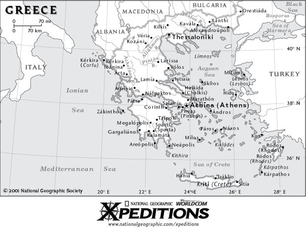
Physical maps of ancient Greece; copies of "The Naming of Athens" myth; pictures of Greek architecture, the Parthenon, the west pediment marbles, and various Greek vases; construction paper, markers, scissors, etc.
MASTERY OBJECTIVES:
By the end of the lesson, students will be able to:
a. Identify key features of Greece's physical geography
b. Explain how geography affected the agriculture and overseas trade of
Athens
c. Describe and model the Greek style of vase painting
ACTIVITIES AND INVOLVEMENT:
Day 1:
a. Students will locate Athens on a map of Greece. The teacher
will lead a discussion of how Athens was affected by its geography, asking
questions like:
- What do you notice about the physical geography around Athens?
- Do you think this was a smart place for people to settle? Why or why
not?
- With whom might the Athenians have had regular contact?
b. The students will break into small groups and discuss the questions,
"What might have been the advantages of settling in this location?
The disadvantages?" After a few minutes of discussion, groups will
share their thoughts with the class.
c. In the course of a whole-group discussion (with help from the
teacher, as necessary), students will annotate their maps, taking note
of these facts:
- Athens is in a mountainous region, and it is close to the sea.
- The terrain made farming difficult for early Athenians, and they therefore
had to result to trade for many of their needs.
- Grapes and olives were products that grew well on Athens's hillsides,
and could then be traded for other products.
- Athens's location near the sea was ideal for overseas trade.
Day 2:
In their Language Arts class, students will read and discuss the myth, "The Naming of Athens."
Day 3:
a. The teacher will review the myth, "The Naming of Athens,"
with the students, emphasizing the connections the myth has to previously
studied information about Athens's geography, agriculture, and trade.
b. The teacher will show students pictures of Greek architecture,
specifically identifying the pediment of a building. The students will
identify the pediment on a picture of the Parthenon. The teacher will
then show students pictures of the Parthenon's west pediment, in both
the original ruins and a complete copy of the original in Nashville, TN,
explaining that the west pediment depicts the myth of Athens's naming
that they read.
c. The teacher will tell students that they are going to be creating
their own representation of this myth in a form that was very popular
in ancient Greece: the painted vase. Rather than painting an actual vase,
they will be modeling the technique on paper. The teacher will show students
pictures of various painted vases from ancient Greece, identifying common
elements such as the black backgrounds with red figures (or vice versa
on earlier vases), decorative borders with repetitive patterns, realistic
figures, etc.
d. Students will first sketch their scenes on scratch paper, and
will then be given construction paper, markers, scissors, etc. to create
their finished product.
ASSESSMENT AND CRITERIA FOR SUCCESS:
a. Students' annotated maps will include all information listed
above, and will be completed according to the criteria on the accompanying
rubric.
b. During class discussions, the teacher will informally assess
students' understanding of the effects of Athens's geography, and of how
these effects are represented in the myth about Athens's name.
c. Student vases will accurately depict some element of the myth
about the naming of Athens, and will accurately reflect the style of Greek
vase-painting. They will be completed according to the criteria on the
accompanying rubric.
CONNECTION TO CURRENT CURRICULUM:
This lesson is directly connected to several important concepts in the
6th grade world studies curriculum. There are three key content standards
that are covered. They are:
a. MCPS Social Studies Content Standard 3.3.6.2.a: Analyze the
major cultural achievements of Greek civilization in art, science, literature,
and philosophy. The exposure to Greek architecture and vase-painting
reflect the "art" portion of this standard, and the analysis
of the naming myth, though it is actually a re-telling of a piece that
would have been originally passed down orally, is related to the "literature"
portion.
b. MCPS Social Studies Content Standard 4.1.6.4.b: Describe
the influence of physical and human characteristics on the development
of Greek city-states and on trade patterns in the Mediterranean. By
discussing how surrounding geography limited the crops Athenians could
grow and forced them to turn to trade for many of their needs, students
will be connecting physical characteristics to the development of Athens,
and to its eventual trade dominance in the region.
c. MCPS Social Studies Content Standard 4.3.6.5.a: Locate and
describe major economic activities of ancient Greece, including regional
trade and agriculture. Through discussion and map annotation, students
will become aware of some of the major agricultural staples of the Athenians,
and of why and how they traded for other products.
CONNECTION BETWEEN SOCIAL STUDIES AND THE ARTS:
It is impossible for students to adequately explore social studies without
studying the arts; the two disciplines are innately connected. Social
studies is the study of human interaction, and the arts are some of the
most influential and interesting ways that humans often choose to interact.
Likewise, artists find their inspiration in the world around them, so
to understand a piece of art, one must understand the time and context
in which it was created. Their arts were an important part of how the
ancient Greeks defined themselves as Greeks, particularly in Athens. By
introducing students to specific types of art created by the Athenians,
students will be able to make concrete connections when we discuss Athens's
rise as the one of the main cultural centers of the ancient world. By
having students create a simulation of an ancient Greek art form, they
are able to make a personal connection with a topic that might otherwise
feel quite foreign, leading to a deeper understanding of the role of the
arts in Greek society and how they fit into the larger picture of Greek
life.
MS Word version of "The Naming of Athens"
Map of Greece from National Geographic Expeditions in GIF or PDF.
We welcome your comments
and suggestions
The Center for Renaissance & Baroque Studies
0139 Taliaferro Hall
The University of Maryland
College Park, Maryland 20742
301-405-6830
Last updated August 1, 2002.